The geographic information system (GIS) is a system for gathering, processing, and presenting data based on geographical references.
This section describes how locations are displayed using the different mapping systems. There are five grid display modes supported in Harmony Enterprise:
1. Cartesian
4. National Topographic Map Numbering System (NTS)
5. Universal Transverse Mercator (UTM)
Cartesian
Cartesian coordinates describe a location in terms of distance from a defined reference point. The X axis, which represents longitude, increases in the east direction. The Y axis, which represents latitude, increases in the north direction.
Example location: -317 km, 6532 km
|
X Axis (East/West) |
Y Axis (North/South) |
|
317 km west |
6532 km north |
East / West: The negative sign indicates that the location is to the west of the defined reference point.
North / South: The location is to the north of the reference point. In most cases this reference will be the equator.
Dominion land survey
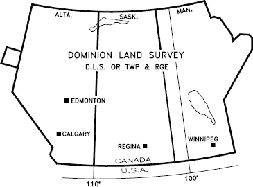
The Dominion Land Survey (DLS) system is used in the Canadian provinces of Alberta, Saskatchewan, Manitoba, and a small portion of British Columbia.
Areas in Canada where the DLS system is used:
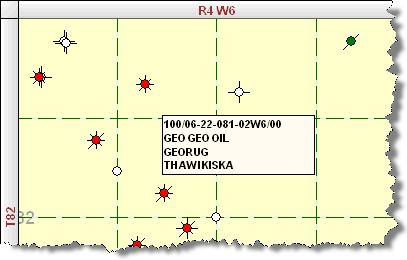
Example Location: 100/04-11-082-04W6/0
We can read the parts of the unique well identifier (UWI) as the following:
|
UWI Format |
Location Exception |
Legal Subdivision |
Section |
Township |
Range |
Meridian |
Event Sequence Code |
|
1 |
00 |
04 |
11 |
082 |
04 |
w6 |
0 |
UWI format
This number identifies the use of a DLS system.
Location exception code
This is used when there is more than one well drilled per legal subdivision. For more details on what can be included in the exception code, see Energy Resource Conservation Board's Guide 59.
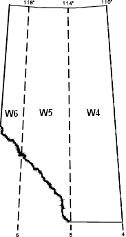
Meridian
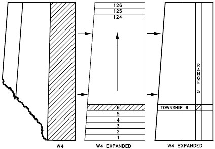
The meridians are 4 degrees of longitude wide that divide the DLS provinces. The First or Primary Meridian is located at 97o27' 28.41" west, which is just west of Winnipeg, Manitoba. Meridians west of the Primary Meridian are designated sequentially as "W1M", "W2M" to "W6M". Similarly, meridians east of the Primary Meridian are designated sequentially as "E1M", "E2M", etc. The fourth meridian west of the Primary (W4M) corresponds to 110 degrees west, and forms the Alberta-Saskatchewan border.
The meridians corresponding to Alberta, Canada:
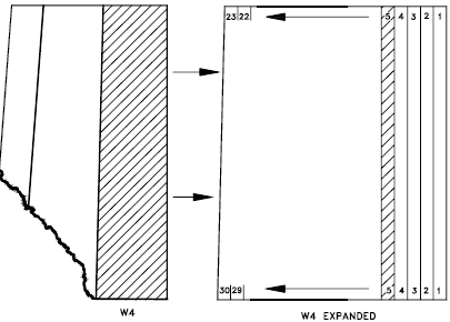
Range
The ranges further divide the meridians. At the southern edge of Alberta, there are 30 range lines per meridian. The number of ranges per meridian decreases as the latitude increases. Each range is 6 miles (9.7 kilometers) wide.
Ranges in Alberta:
Townships
The townships divide the provinces up in the north-south direction from the Canada-USA border to the Arctic Circle. There are 126 township lines in Alberta. Each township is 6 miles (9.7 km) north-south.
Expanded view of ranges in Alberta:
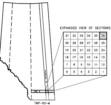
Sections
A square one range wide by one township north-south contains 36 sections. Each section is 1 mile (1.6km) per side.
Expanded view of sections:
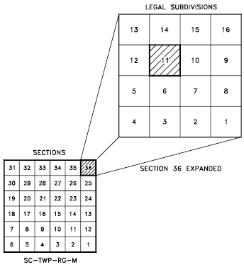
Legal subdivision
Each section is further divided into 16 legal subdivisions (LSD). An LSD is the smallest division in the DLS system. Each LSD is a square of one-quarter-mile, or 1320 ft (402m) per side.
Expanded view of LSD:
Event sequence
Indicates chronological sequence of drilling or completion activities.
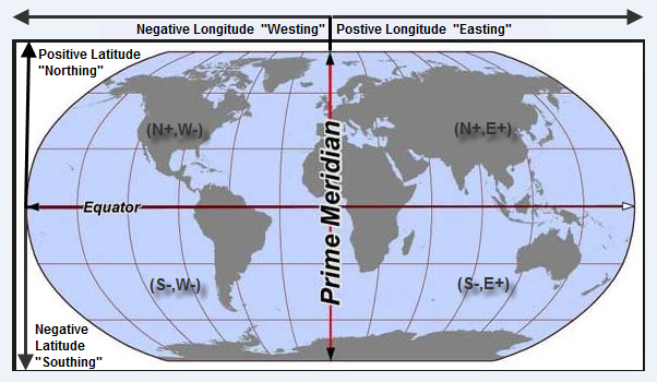
Latitude / longitude
Latitude is a measure of how far a point is from the Earth's equator. Latitudes may vary from 0 to 90 in both north and south directions. Latitude lines are all parallel. There is a constant distance separating latitude lines of about 110 km (69 miles) per degree.
Longitude is an angular distance that is measured using the prime meridian as a reference. The prime meridian is an imaginary line that connects the North and South poles while passing through Greenwich, England. The ranges for longitudes are 0 - 180 East and West. Longitude lines are not parallel. The distance between two points that are separated by a fixed longitude depends on their latitude. Longitude varies from about 110 km (69 miles) per degree at the equator to a few meters (or feet) per degree at the poles.
To further divide degrees of latitude and longitude seconds and minutes are used:
- 1 degree = 1o = 60 minutes
- 1 minute = 60 seconds
Since Harmony Enterprise only accepts a decimal notation for latitude and longitude, you need to convert your values. You can use an online calculator. Or convert by hand, by dividing the minutes by 60 and the seconds by 3600 (60 x 60), followed by adding these values together with the degrees. If you attempt to bring in latitude / longitude, Harmony Enterprise does not read the directional script typically given at the end of a coordinate pair (e.g., N for "Northing", etc.). Instead, Harmony Enterprise reads whether the number is positive or negative.
As an example of latitude and longitude, here are the approximate locations of a few cities around the world:
| Location | Latitude | Longitude | Notes |
|---|---|---|---|
|
Greenwich, England |
51o, 29 min N |
0o, 0 min |
This is the reference point for longitude. |
|
Calgary, Canada |
51o, 3 min N |
114o, 3 min W |
This city is located north of the Equator and to the west of Greenwich. |
|
Perth, Australia |
31o, 57 min S |
115o, 52 min E |
This city is located south of the Equator and to the east of Greenwich. |
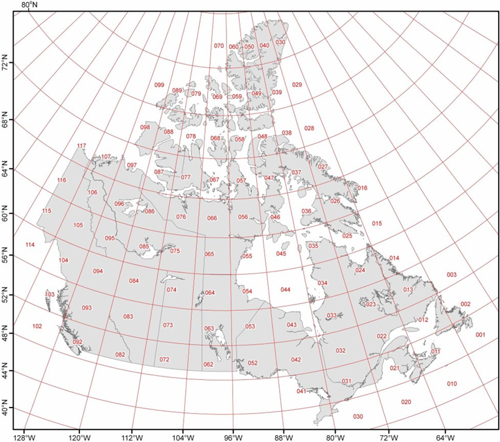
National topographic map numbering system
The National Topographic Map Numbering System (NTS) is a system used by Canada to provide general purpose maps of the country.
Example Location: a-10-D-93-P-2
|
Quarter Units |
Units |
Blocks |
Series Numbers |
Map Areas |
Map Sheets |
|
a |
10 |
1 |
93 |
P |
8 |
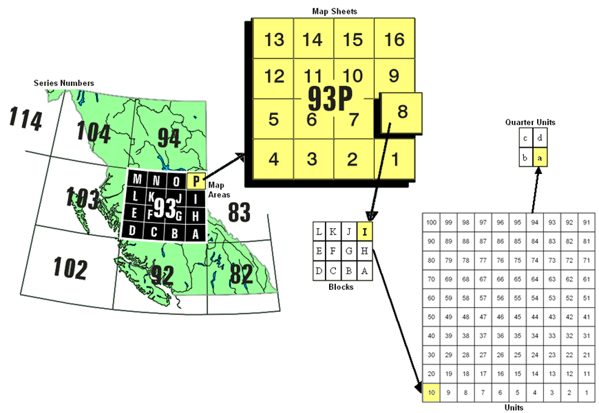
Series numbers
The series numbers identify rectangular areas that have a width of 8 degrees of longitude (width) and 4 degrees of latitude (north south). Series number 93 is located in the province of British Columbia.
Map areas
The map areas divide the series numbers into 16 pieces that are labeled A to P. Each map area is 2 degrees of longitude (width) and 1 degrees of latitude (north south).
Map sheets
Each map area is divided into 16 numbered map sheets.
Blocks
The map sheets are divided into 12 blocks that are labeled from A to L.
Units
The blocks are subdivided into 100 units. The direction of the numbers is always towards the left, unlike the numbering of map sheets.
Quarter units
Each block is subdivided into quarter units labeled a to d.
Universal transverse mercator
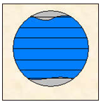
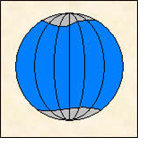
The universal transverse mercator (UTM) grid is an attempt to draw the earth on a cylindrical projection. The word transverse implies that the cylinder is "wrapped" around the earth in a north-south direction, as shown in the following figure.
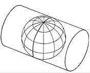
The equator is used as the reference point in the north/south direction. The east/west reference is decided upon by the user. Caution should be used in using coordinates that are very far apart as UTM zones are intended to be only 6 degrees longitude in width.
Example location: 317km W, 6532km N
|
East/West |
North/South |
|
317 km west |
6532 km north |
East / West: The location is 317 km (198 miles) to the west (W) of longitudinal reference point.
North / South: The location is that the well is 6532 km (4083 miles) to the north (N) of the equator.