When opening an existing cross section or building a new one, for each enabled Petrophysical or Cutoff Zone (starting from version 8.1), AccuLogs automatically generates or updates the well record in the corresponding CSV files. Output data can be gridded and contoured in AccuMap using kriging or other methods.
AccuLogs constructs the output file name by concatenating three keywords separated by underscores:
- Keyword is Aclgs indicating AccuLogs generated data
- The Name of the Cutoff Zone or the Name of the Petrophysical Zone defined in the Global Digital Zone Definitions or Global Petrophysical Definitions dialog
- Keyword is Cutoff for cutoff zones or RsvrProps (Reservoir Properties) for petrophysical zones. For example for a Cutoff Zone defined as VikNPT the corresponding output file name with the file extension would be Aclgs_VikNPT_Cutoff.csv. AccuLogs writes the output file with identical name and content into two destination folders:
AccuMap Working Folder, which is displayed in AccuMap Classic on the left side of status bar. The output file in this folder is intended for AccuMap Classic and will be automatically updated when you build a new cross section.
and
AccuLogs Application Data folder. The output file in this folder is intended for new AccuMap. You have to point to this file when creating a contour map from CSV data (by typing %appdata%/AccuLogs in the File Open dialog).
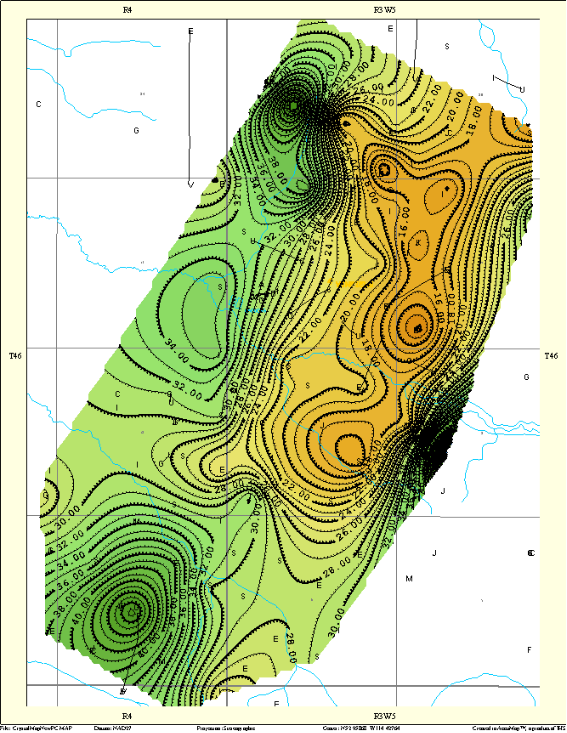
Cutoffs that define the Net Pay Flag dramatically changed over the recent decade by applying advanced multistage fracturing technologies and improved recovery techniques. Generally for the same area you can use several cutoffs to generate multiple Net Pay Thickness maps (to see which part of the pool or field can be developed using vertical wells, and which requires horizontal drilling). Because of this, AccuLogs enables you to generate two types of mappable parameters: 1st - based on the Petrophysical Zone Definitions (Cumulative or Average Properties for Sandy Rocks), and 2nd - based on the Cutoff Zone Definitions (mainly intended to calculate Net Pay Thickness using raw or on-the-fly generated curves and economically based cutoffs).
To generate cumulative and average properties based on the Petrophysical Definitions that AccuLogs uses SANDFLAG = 1 - if VSH <= VSH CUT; 0 – if VSH > VSH CUT,
Where VSH CUT is the Vshale cutoff entered in Global Petrophysical Definitions dialog.
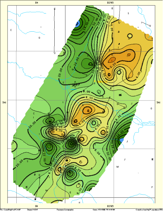
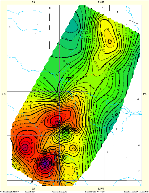
Cumulative Reservoir Properties for Sandy Rocks
- HPV (VSH < Cutoff) - Cumulative Hydrocarbon Pore Volume for Sandy Rocks (meters per unit area)
HPV = SUM (PHIe * (1 - Sw) * THICK * SANDFLAG)
- PHI*H (VSH < Cutoff) - Cumulative Pore Volume for Sandy Rocks (meters per unit area)
PV = SUM (PHIe * THICK * SANDFLAG)
- (1 – VSH)*H (VSH < Cutoff) - Cumulative Sand* Volume (meters per unit area)
SV = SUM ((1 – VSH) * THICK * SANDFLAG)
Remarks: * - Sand in this case means any type of low shaly rocks (sand, limestone, coal etc.). - Low VSH Thick (VSH < Cutoff) – Total Thickness Low Shaly Rocks (meters)
Low VSH Thickness = SUM (THICK * SANDFLAG)
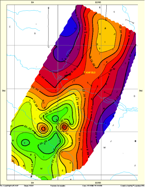
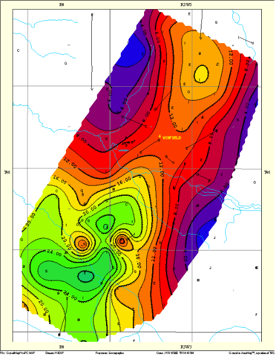
Average Reservoir Properties for Sandy Rocks
- PHIavg (VSH < Cutoff) – Average Porosity for Sandy Rocks (per cent)
PHIavg = SUM (PHIe * THICK * SANDFLAG) / SUM (THICK * SANDFLAG)
- SWavg (VSH < Cutoff) - Average Water Saturation for Sandy Rocks (per cent)
SWavg = (1 - HPV / PV) * 100%
- VSHavg (VSH < Cutoff) – Average Shale Volume for Sandy Rocks (per cent)
VSHavg = (SUM (VSH * THICK * SANDFLAG) / SUM (THICK * SANDFLAG)) * 100%
- RESmax (VSH < Cutoff) – Maximum Deep Resistivity for Sandy Rocks (Ohmm)
Since in most wells at least deep resistivity and gamma ray logs are recorded, this parameter enables AccuLogs to get more acceptable area coverage for mapping thin reservoirs than other petrophysical properties that require porosity log to get estimation. - Lg10ResMax (VSH < Cutoff) – Logarithm of Maximum Deep Resistivity for Sandy Rocks
In some cases this parameter is more suitable for reservoir mapping because the logarithm of the resistivity is less sensitive to outliers (abnormally high resistivity values).
Average and Maximum Log Readings
- GRavg – average GR value in API units.
- RESavg – average deep resistivity in Ohmm.
- DTavg – average compressional DT in microseconds per meter.
- DENSavg – average bulk density in kilogram per cubic meter.
- TOCavg – average Total Organic Carbon (%) estimated using DT and deep resistivity.
- CONDUCTIVITYmax – maximum conductivity in millisiemens calculated from deep resistivity.
Positioning Parameters
UWI – mandatory parameter required by AccuMap for gridding and contouring well data stored in CSV format.
Top Hole Longitude, Top Hole Latitude, Bottom Hole Longitude, and Bottom Hole Latitude – positioning parameters intended for 3rd party mapping applications.
Interval Top Depth, Interval Base Depth, Interval Top Subsea, Interval Base Subsea – parameters defining TVD and subsea interval where cumulative or average parameters were calculated. Parameters intended for 3rd party applications (for example to post reservoir properties into seismic sections or other vertical profiles).
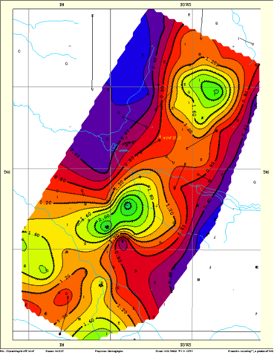
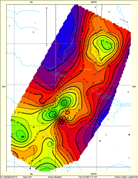
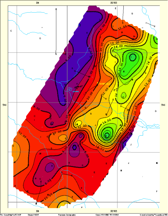
Net Pay Thickness and Mappable Parameters for Cutoff Zones
AccuLogs Cutoff Zone Definitions (starting from 8.1) enables you to generate a CSV output file, which can be used in AccuMap to create a Net Pay Thickness map like the one shown below.
Cumulative thickness of layers that meets criteria defined in Cutoff Zone Definitions named in output CSV file as Total Cutoff Thickness (measured in meters). Economically based cutoffs can be applied to the following:
- On-the-fly calculated petrophysical parameters, such as PHIe and Sw (note: the corresponding petrophysical zone must be enabled to generate curves required by cutoff criteria)
- Raw curves like GR and Deep Resistivity
- A combination of raw and on-the-fly generated curves (for example PHIe and Deep Resistivity)
First Layer Top Depth, First Layer Top Subsea – additional parameters that define the top of the first layer within the cutoff zone that meets user-defined criteria (TVD and subsea in meters).
Last Layer Base Depth, Last Layer Base Subsea – additional parameters that define the base of the last layer within the cutoff zone that meets user-defined criteria (TVD and subsea in meters).
First and Last Layer mainly intended for 3rd party applications (for example to post into seismic sections or other vertical profiles).