
Keep in mind that elevation KB is the number one parameter for correct structural presentation, so ensure the following:
No abnormal Min Max values appear on the map color gradient or interest area (see normal range below)
No bull’s eyes appear in the map area (see example below)

1. Ensure there are no incorrect hub elevations in the map display area. You can fix incorrect hub elevations using steps 4 and 5 below.
Note Each well involved in the gridding and contouring process should have a posted Z-value.
2. For wells without Z-values, from the Properties menu, select Map and clear the ignore deviated wells checkbox.
Also keep in mind that all new wells usually come from the hub with elevation –99999. This means that no elevation value is currently available. Wells with missing elevations are displayed on the map using well symbols only and are excluded from gridding and contouring.
3. To fix incorrect elevations or redefine deviation flags, right-click the well and from the popup menu, select general info dlg.
The General Well Information dialog box appears.
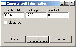
4. Type a correct elevation KB or select the deviation checkbox then click OK.
